

AI2Peat: remotely monitoring Ireland’s peatlands for conservation and restoration
In association with Research Ireland
Peatland covers a significant amount of Ireland’s land surface area, around 23%, according to the most recent estimates from Trinity College Dublin’s RePeat Project. Peatland stores a huge amount of carbon, making the upkeep of this land incredibly important for Ireland’s 2030 climate targets.
“These landscapes cover such a vast area, and they can often be quite inaccessible. In the case of blanket bogs in particular, there are gaps in what we need to monitor and what we can feasibly monitor. The problem is, if we can’t monitor and assess improvements, then we can’t report on those improvements, and we don’t know where we need to prioritise conservation efforts,” explains Katie Smirnova, researcher with AI2Peat.

AI2Peat, which is one of the projects supported by the National Challenge Fund, has developed a solution to monitor peatlands for conservation and restoration purposes.
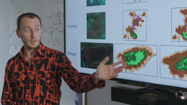
“The monitoring part is done by applying remote sensing based on satellite imagery. We then use machine learning to identify patterns in peatland conditions. We also collaborate with experts within the National Park and Wildlife Service who have specific peatland knowledge and they provide us with the expertise and the steering. We apply machine learning and data science to make sure that what we find is useful, relevant, trustworthy, and it represents things that make sense,” says Corrado Grappiolo, AI2Peat project lead.
In situ monitoring remains a vital part of peatland condition monitoring, but remote sensing fills the gaps where people can’t reach. There are of course, aspects of the peatlands that remote sensing can’t currently reliably monitor, explains Katie, including hydrology and the specific species that live in the bogs.
“You need to have both. There are some things that remote sensing hasn’t overcome yet. At the resolutions we have it’s useful to detect change. It can be effectively used to monitor at a larger scale, and to identify areas that need to be prioritised with in situ surveying, which means the people on-site don’t have to cover entire mountain ranges, they can focus on particular hot spots.”
“With AI2Peat we’re not trying to replace peatland monitoring with remote sensing data; this is a tool that can be used to scale up those conservation efforts,” explains Corrado.
”An important part of what we do is engage with stakeholders from different domains – public, private, NGOs, local communities – to identify their needs and how we can contribute. Possibly the biggest need, as I see it, is being able to gather information about peatlands, about past and current projects and keep them all together. It’s very difficult to know who does what, where and when. Projects start and finish and some knowledge is generated, but is often lost or forgotten. There’s a need to find a way to link all these works together.”
Incentivisation
One stakeholder is Peatland Finance Ireland, an organisation working at directing funds towards peatland conservation efforts. Due to their carbon-capturing properties, peatlands have the potential to reduce Ireland’s carbon emissions by 5%. But the restoration of peatlands is not always sufficiently incentivised.
“Peatland Finance Ireland’s Peatland Standard will require the verification of the progress of conservation efforts, which allows for the ecosystem certificates to be reported on. Currently, they might only be able to validate every five years, with monitoring occurring every six months or annually. With remote sensing and machine learning, they’ll be able to do assessments more frequently, which means that more companies will be likely to purchase certificates because they’ll be able to see those reports on them sooner. This is a really tangible example of where the remote sensing imagery can be applied,” says Katie.
The main output of AI2Peat’s data is a platform called PeatSense.org, a repository for data and knowledge, high quality maps, third party maps, and recently captured satellite imagery.
“Through our approach, we can also map vegetation communities – the type of vegetation within a bog, and we can link them to emission factors. Using this information we can provide more precise information on which parts of the bog are carbon emitters, or carbon sinks, essentially the balance of the whole bog. This could be leveraged by other organisations involved in carbon farming and government organisations involved in national reporting on greenhouse gas emissions” says Corrado.
“In order to achieve precise verification, additional ground truth data, via in-situ monitoring, can be fed back to our machine learning models for retraining so that the next iteration of our models are more precise.”
“At the end of the day, the data needs to accurately represent what’s on the ground and be trustworthy. By allowing the project to continue, we can further build on that. And all of that work won’t be lost, but actually will be in a position, hopefully, to contribute to those practical uses. This is important because we’re at the point in the climate and biodiversity crises where we don’t have time to lose, and we need these technologies to be operational. The more funding that can be allocated to this research, and the quicker that the research can become used in practice, the quicker we can advance the restoration needs to meet these targets,” says Katie.
AI2Peat is currently in the Grow Phase of the National Challenge Fund, a €65 million research fund established under the Government of Ireland’s National Recovery and Resilience Plan (NRRP), funded under the EU’s Recovery and Resilience Facility, coordinated and administered by Research Ireland.
It joins four other teams in the Future Digital Challenge group, which is focused on transformational societal and economic impact from disruptive digital technologies. These four teams will have the opportunity for additional funding in the final phase of the programme, where prize funding of €1 million is on offer.


Subscribers 0
Fans 0
Followers 0
Followers